Suburbs, Highways, Redlining, and White Flight
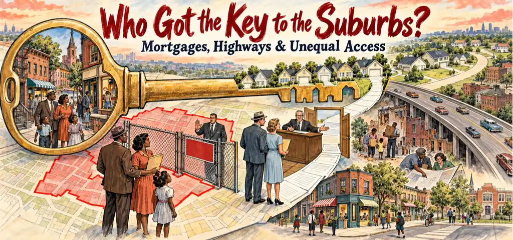
Chapter 12 of the CLEP History of the United States II study guide on Effortless Math covers Suburbs, Highways, Redlining, and White Flight: the key terms, the core ideas, and worked examples showing how this topic is tested on the exam.
CLEP History of the United States II, Chapter 12
Postwar suburbanization joined demographic demand to public policy
Marriage, the baby boom, rising incomes, and housing shortages created demand for new homes after 1945. Builders found cheap land beyond city limits, while automobiles widened the commuting radius. Public decisions shaped that market: mortgage insurance lowered financing costs, road construction opened land, zoning controlled density, and local governments supplied schools and utilities. Suburbs were neither a purely private consumer choice nor simply a federal construction project. They emerged from households acting inside subsidized credit and infrastructure systems.
Automobiles changed suburban form before the postwar boom
Streetcars had already pushed development along fixed routes, but mass automobile ownership and paved roads filled land between the lines during the 1920s. Passenger-car registrations nearly tripled during the decade, and many suburbs grew faster than their central cities before FHA insurance or the Interstate system existed. The later postwar boom added federal credit, mass-produced houses, highways, and baby-boom demand to an older automobile-driven shift. Correct chronology prevents assigning every suburban change to a 1950s program.
Mortgage reform changed the structure of monthly ownership
Many 1920s mortgages covered roughly half a home's value, lasted only a few years, and left a large principal payment due at the end. FHA insurance encouraged longer, amortized loans with regular payments, and VA guarantees extended favorable credit to veterans. These designs made ownership resemble a manageable monthly expense for more salaried families. Government did not ordinarily lend the entire price itself; it defined and insured risks that private lenders would accept.
Underwriting converted racial hierarchy into credit allocation
FHA manuals treated racial "inharmony" as a threat to property value, while Home Owners' Loan Corporation maps gave low grades to many Black and immigrant neighborhoods. Appraisals and insurance directed mortgage capital toward new, racially homogeneous subdivisions and away from older districts. Redlining did not merely describe poverty after it occurred. It helped produce uneven investment by making favorable credit harder to obtain, encouraging deterioration that could then be cited as proof of risk.
Levittown joined mass production to exclusion
Levitt and Sons divided construction into repeated specialized tasks, purchased materials at scale, and built thousands of similar houses on Long Island beginning in 1947. Standardization lowered cost and accelerated supply. Contracts barred nonwhite occupancy, while mortgage institutions supported the development. In 1948 Shelley v. Kraemer made judicial enforcement of racial covenants unconstitutional, but developers, brokers, lenders, and residents retained other discriminatory practices. Ending court enforcement did not instantly create equal access to credit or sales.
Highways redistributed access and cost
The Federal-Aid Highway Act of 1956 funded the Interstate system largely through a Highway Trust Fund supported by federal fuel taxes. Roads aided long-distance commerce, defense planning, tourism, and suburban commuting. Routes through cities frequently cleared Black and working-class neighborhoods whose residents had less political power to redirect them. A highway could raise the value of outlying land while destroying property and networks along its urban path. Infrastructure benefits and displacement costs were spatially unequal.
White flight created a metropolitan fiscal feedback
As white and middle-income households moved outward, many jobs and retail purchases followed. Central cities retained large obligations for transit, schools, policing, and aging infrastructure while their tax bases weakened. Suburban municipalities could use zoning to limit apartments or low-cost housing and keep access to high-value schools geographically bounded. Racial fear, credit rules, new supply, and municipal finance reinforced one another. White flight was not one family moving; it was a cumulative market and governmental process.
One economy could contain many governments
Commuters, employers, housing markets, and transportation networks crossed city lines, but metropolitan authority remained divided among central cities, suburbs, counties, school districts, and special authorities. A suburb could control zoning and retain its tax base while residents used jobs or institutions elsewhere in the region. The resulting mismatch complicated regional housing, transit, and service finance: the economic area was shared, but budgets and land-use powers were not. Fragmentation did not automatically make every suburb wealthy or every central city poor. It made benefits, costs, and decision-making uneven across municipal borders.
Urban renewal cleared land but displaced communities
Title I of the Housing Act of 1949 financed city acquisition and clearance of areas labeled blighted, after which land could be transferred for redevelopment. Officials promised modernization and a stronger tax base. Black and low-income neighborhoods lost homes and businesses disproportionately, and replacement housing often lagged. Critics called the process "Negro removal." The program's formal target was deteriorated property, but definitions of blight and political power determined whose neighborhood was erased.
Public housing siting concentrated disadvantage
Cities such as Chicago placed many high-rise projects in already Black districts because white aldermen and residents blocked other sites. Concentrating very poor tenants in isolated towers while underfunding maintenance and services created severe institutional burdens. Later litigation such as Gautreaux challenged discriminatory siting and promoted scattered alternatives. The lesson is not that tall buildings mechanically cause poverty. Tenant selection, location, segregation, management, transport, and public investment shaped outcomes.
Retail followed automobiles into planned centers
Suburban shopping centers assembled stores under one management, supplied large free parking areas, and oriented circulation around drivers. Southdale Center near Minneapolis opened in 1956 as an enclosed, climate-controlled mall separated from the traditional street grid. Its controlled interior imitated public space while remaining privately managed. Downtown retail districts, by contrast, mixed ownership, streets, transit, offices, and civic uses. Shopping geography followed both suburban households and the infrastructure that made driving routine.
Jane Jacobs defended complexity against clearance
In The Death and Life of Great American Cities (1961), Jane Jacobs argued that mixed uses, short blocks, varied building ages, and many people using streets at different hours could support safety and vitality. She opposed planners who treated apparent disorder as a reason for wholesale clearance. Her argument did not deny the need for sanitation, housing repair, or infrastructure. It challenged the assumption that a superblock designed from above necessarily functioned better than a dense neighborhood with informal observation and multiple uses.
Later programs changed tools without ending spatial conflict
Congress created the Department of Housing and Urban Development in 1965. Model Cities in 1966 combined neighborhood rehabilitation with social services and resident planning, contrasting with earlier clearance-centered renewal. In the late 1960s Chicago's Contract Buyers League organized Black families trapped in inflated installment contracts outside ordinary mortgage protection. After 1970 gentrification brought investment to some older neighborhoods while higher rents and property values displaced lower-income tenants. Disinvestment and reinvestment could both impose unequal costs.
separate preference from structured opportunity
A survey says families preferred yards and new houses, while loan records show racial exclusions and highway maps show public access.
Metropolitan inequality accumulated through linked institutions
Mortgages, covenants, appraisals, highways, zoning, renewal, public housing, schools, and retail centers reinforced spatial boundaries. No single policy created the metropolis, and formal legal change did not erase earlier wealth gaps. To analyze a map, identify who financed movement, who controlled land use, who paid displacement costs, and which jurisdiction received the tax base. Space is a historical outcome, not a neutral stage.
Watch the history in motion
This short lesson adds voices, images, and chronology to the ideas you just studied.
Video: Housing Segregation and Redlining in America: A Short History | Code Switch | NPR, NPR.
Try four CLEP-style questions
- Appraisers downgrade a neighborhood, lenders then reduce mortgage and repair credit there, and physical conditions worsen. Which mechanism best describes that sequence?
- The risk label becomes partly self-confirming by restricting the investment needed to disprove it.
- Households sort among municipalities because each offers a different package of taxes and services.
- Clearance displaces residents before redevelopment replaces the demolished housing and businesses.
- Public housing concentrates hardship when officials restrict projects to already segregated districts.
- Reinvestment raises property values rapidly enough to price out existing renters and merchants.
- Which paired evidence would best measure both the benefits and the costs distributed by a new metropolitan expressway?
- Suburban traffic counts paired with the total mileage opened in each construction year
- Access and land values near exits paired with parcel-level displacement and relocation outcomes
- Land values near exits paired with the central city's aggregate population change
- Military travel estimates paired with the share of construction paid by Washington
- Construction payrolls paired with fuel-tax revenue collected throughout the state
- Officials claim that urban-renewal clearance followed neutral definitions of blight. Which evidence would best test whether political power influenced whose property was taken?
- Project-level appraisal rules, site decisions, resident demographics, and relocation outcomes
- A national count of all housing units constructed during the same decade
- Opinion surveys asking suburban buyers why they preferred detached houses
- Traffic volumes recorded on highways that did not pass through renewal districts
- Mortgage terms offered to borrowers purchasing newly built suburban homes
- An older neighborhood first loses ordinary mortgage credit, then decades later attracts luxury conversions that sharply raise rents. Which conclusion best connects the two periods?
- The later investment proves that the earlier credit withdrawal caused no lasting harm.
- Rising property values necessarily restore displaced tenants to their former homes.
- Capital withdrawal and rapid reinvestment can burden residents through different mechanisms.
- The two periods reflect the same shortage of capital and therefore the same remedy.
- Once private investment returns, zoning and tenant protections cease to affect displacement.
Check your answers and reasoning
Independent preparation. CLEP is a registered trademark of the College Board, which does not endorse this lesson.

Related to This Article
More math articles
- Top 10 TExES Core Subjects EC-6 Math Practice Questions
- Colorado CMAS Grade 6 Math Free Worksheets: Printable Grade 6 Math Practice with Full Solutions
- Institutional and legal barriers to participation
- Dominant Culture, Subcultures, and Countercultures
- Billionaire Basics: How to Master Addition and Subtraction of Massive Whole Numbers
- Perimeter: Locate the Absent Side Lengths
- Free Grade 6 English Worksheets for Washington, D.C. Students
- CLEP U.S. History I 004: French and Dutch Colonization
- How to Compare Fractions?
- How to Solve Inverse Trigonometric Functions?




















What people say about "Suburbs, Highways, Redlining, White Flight"?
No one replied yet.